

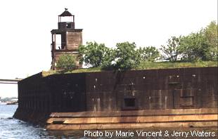
 Fort
Carroll Light was originally built on a parapet of Fort Carroll in 1854
with a sixth order Fresnel lens. The lighthouse and fog bell were removed
in 1898 to make room for the forts expansion. A new light was constructed
in December of the same year; a square wooden tower with black cast iron
lantern with a fifth order Fresnel lens. What remains is the ruined square
cylindrical frame tower from 1898. The fifth order Fresnel lens was removed.
Fort
Carroll Light was originally built on a parapet of Fort Carroll in 1854
with a sixth order Fresnel lens. The lighthouse and fog bell were removed
in 1898 to make room for the forts expansion. A new light was constructed
in December of the same year; a square wooden tower with black cast iron
lantern with a fifth order Fresnel lens. What remains is the ruined square
cylindrical frame tower from 1898. The fifth order Fresnel lens was removed.
Fort Carroll and the lighthouse sit atop a man-made island in the middle of the Patapsco River. The hexagonal fort was built to protect the approach to Baltimore. The fort was abandoned after the end of World War I and the light was automated in 1920. During World War II the fort was used as a firing range and to house foreign seamen while their ships were fumigated. The light was deactivated in 1945.
The fort was sold into private ownership in 1958. In 2000 a local developer signed a lease on the property; no purpose has been announced. Obviously endangered and in a state of decay, the light is on the Lighthouse Digest Doomsday List.
 2001(c) Chesapeake Chapter, USLHS. All rights reserved.